Showing posts with label Fly fishing. Show all posts

Monday, February 4, 2013

The Fly Fishing Season: When is runoff over?


In the American west there is no hard and fast date for when runoff from snow melt is over.  It varies from year to year based on the winter’s snow water equivalent, and from location to location due to regional climatic differences.  Of course the best way to know the optimum time for summer fly fishing is to have some years of experience and to have either a written or mental logbook of when runoff is over and the rivers have reached their fishing peak.


But what about trying to get your timing right in an area you have no experience with?  Here is a semi-scientific way, based on USGS long-term hydrographs of estimating the best time.  A quick refresher on runoff and stream flow http://streamsideadventures.com/tips-and-techniques/stream-flow-and-fly-fishing-runoff-hydrographs.html and also how a stream gauge works http://streamsideadventures.com/tips-and-techniques/stream-flow-and-fly-fishing.html will help you with making your estimate.  


One of the things you will note when you look at a snow melt stream’s hydrograph is that at the start of summer you see the “peak flow” and late in the summer the stream
Understanding stream flow
flow reaches a rather consistent level, what hydrologists call the “base flow.”  Some place in between these two points is the best time to fish.  But when?


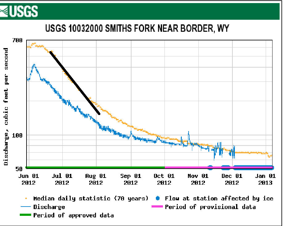
As you look at the hydrograph you will generally notice a point in time when the slope of the hydrograph makes a bit of a change.  A good way to find this is to draw a line, starting at the peak, along the points on the hydrograph. 

Runoff understanding for better fly fishing

The place where the individual data points veer away from your line is a very good estimate of when the major period of runoff is over!  Sometime around that date – plus or minus a about a week – is your prime fishing time.

Monday, November 19, 2012

START PLANNING NOW FOR YOUR SUMMER TRIPS


I know it isn’t even December yet but we need to start thinking about our fishing trip(s) for 2013 if we want to have the best trip possible.  Here are a few simple tips that I think will help you have a great 2013 fishing season.

Be as flexible in scheduling your trip as you can possibly be.  For many people last year’s trip was a complete bust.  Nearly every area of the west was in drought conditions.  Rivers were too low to float and the water was too warm to fish. It is much too early to be deciding on when you are going to make a summer trip out west.  It will still be too early in the middle of January to mark your calendar.  I generally hold off until mid-April.  By then the maximum amount of snow has fallen.  If you don’t have scheduling flexibility and have to determine your dates soon, you can make an “educated” guess by checking USGS gauging stations in the area you are interested in and seeing what the long-term runoff hydrograph looks like.  Remember that long-term value is the median values for many many years of record.  The last two years are perfect examples of variability in stream flow.  2011 was an extremely heavy snow year.  In the mountains there were still patches of snow into August. 
                                            
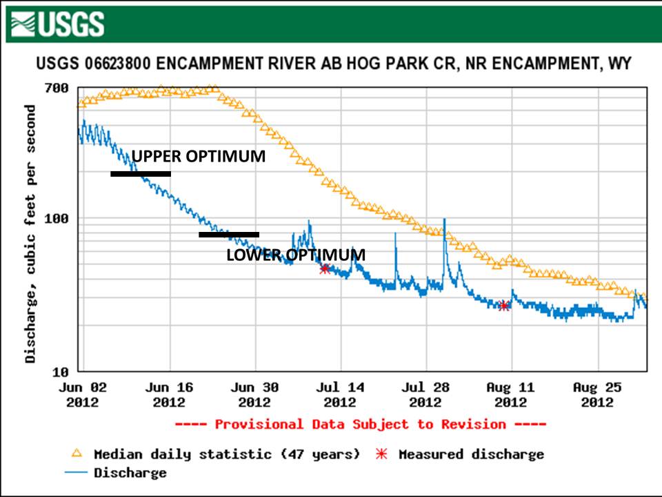
With all the snow, both the volume of runoff and the duration of the runoff season, was greatly extended.  For the Encampment River the optimum fishing flows were not reached until almost the 1st of August.   

                                             
2012 was the opposite of 2011 for both snow fall and runoff.  This past summer with the winters 

                                               
exceeding low snow falls the Encampment's optimum fishing time was weeks earlier than normal. 


All the folks that made their plans based on what they knew or expected from previous years were very disappointed.    
                   
Information on snow levels throughout the west are readily available for the US Department of Agriculture’s SNOTEL system.    


First click on the state you are interested in, say Wyoming.  On the state map you can click on the SNOTEL stations in the area you are planning to fish to see what the snow levels are.  Start doing this now and return every few weeks to see how the snowpac is progressing.   


 Start doing this now and return to the sites every few weeks to see how the snowpac is progressing.  Generally by early April you will know what the runoff potential will be and be able to mark you summer fishing calendar. 

Define your trip objectives and set realistic expectations.   If your trip is taking you to a new location, on your own, an expectation of lots of fish and lots of big fish will likely be a recipe for disappointment.   In a new area, on your own, you can often “figure” the area out.  But if you are going on a family vacation and expect to be able to get enough stream time in to learn the area, you are likely to be disappointed.  If finances permit hire a guide.  Guides know the area and the subtle nuances that make a day on the stream more rewarding.  But don’t expect you guide to give everything up to you.  There is a sixth sense that lets us know when clients are just trying to find your locations.  I learned this hard way in Chile.

Getting the information you need.  There are a lot of book out there about where to fish and even more magazine and online articles about specific regions or rivers.  They have a place in the trip planning process but should not be the considered the definitive word.  A couple of years ago there was an article in Southwest Fly Fishing about the Encampment River.  A longtime client told me about it.  I’ve been fishing and guiding on the Encampment River for 25 years.  The Encampment is one of the wests best if you know it well.  But if I had based my trip – timing, locations and techniques – on that article I would have been very disappointing.   How can someone who may never have fished a river system be able to provide reliable information.

Fly Shops are often cited as a great source of local information.  And, to some extent, they are.  But fly shops see crowds of people during the season and often don’t have the time to offer you valuable advice.  Don’t forget that most fly shops also run guided trips.  You can be pretty sure that they are not going to be sending people to locations where paying clients will be going.  Your best bet for getting valuable information is to establish a relationship with the shop.  Call them during the offseason and ask about the best times to be there, what are the predominate hatches and the like.  Stay in contact with them.  If there is a local special pattern buy a few from them to use as models.  When you show up during your trip, remind them about your previous contacts.  There is a very good chance that you will get information that someone without any history with them will.

A couple of years ago Duane, my friend and fishing buddy, set off on a fly fishing quest to not just complete the California Heritage Trout Challenge but to catch all the catchable species.  We did it with a 10 day 2,800 mile road trip.  We were able to do it so quickly for one reason: We had insider information.  By that I mean we talked to the fisheries management professional for the areas where the different species occur.  They were more than happy to tell us exactly where to go in their area to find the trout we were looking for.  Often times the local manager has a location he or she is especially proud of and will happily tell you all about it.  This “insider trading” has led me to some fantastic and unexpected fishing locations.  How about an old irrigation ditch full of Colorado River Cutthroats!

If you hire a guide: The guide is working for you.  You have the right, and responsibility, to have a qualified and compact-able guide.  When you are booking ask about the guides, their experience and knowledge of local conditions.  A guide may be great as a float trip guide but lousy on a walk-wade trip.

Your responsibility to the shop and the guide is to be brutally honest about you experiences, skill and physical ability.   We once had a client tell us that they have 10 years of experience only to find out that really meant was about 20 days on the stream over a ten year period.   It was a long day on a stream that was rather technical.  Now we quiz folks about what 10 year really means.   The same goes for skill level.  Perhaps the most important consideration is you physical ability, especially on a walk-wade trip.   Wading all day in even moderate current is strenuous.  Add altitude and perhaps a hike in and out and you have a serious workout.  Day one might be OK but the remainder of the trip might be HARD.

Winter trip planning may not be a good as actually being on the water.  But if you do your homework while there is snow on the ground you will have a much better summer trip.

Saturday, September 1, 2012

PRESSURE, RAIN, STREAM LEVELS, AND FLY FISHING


When most fly fishers think about any weather related aspect of their time on the water, generally atmospheric pressure is the first thing that comes to mind.  Much has been written about pressure and fishing, including a little ditty like “Wind from the west – Fishing best – Wind from the east – Fishing least.”  Like so many axioms, there is a degree of truth to it.  Winds in the northern hemisphere flow counter clock wise around a low pressure area.  If the winds are coming from the west, a low pressure area is approaching and the pressure is starting to fall.   Fishing tends to be the best with a falling barometer.  A falling barometer is a harbinger of a weather change.  More often than not the change is rain or snow.
Rain has two effects on the waters we fish.  The first one we always think of is a raise in water level from the runoff.   For more information to help understand runoff follow these links: http://streamsideadventures.com/tips-and-techniques/stream-flow-and-fly-fishing-runoff-hydrographs.html and http://streamsideadventures.com/tips-and-techniques/stream-flow-and-fly-fishing.html.    The second effect, and the one we rarely think of, is on water temperature.

Nimbus clouds are rain clouds.  The mother of all nimbus clouds is the cumulonimbus clouds.  These are the clouds associated severe thunderstorms and the “pop up” afternoon storms of the mountain west.  While nimbus clouds can form at any elevation, many reach an altitude of up 50,000 feet.  It keeps getting colder with increased altitude.  A general rule of thumb is that for each 1,000 feet of elevation the temperature falls by 3 degrees F.  The water vapor falling as rain from those clouds can be very cold,  cold enough to dramatically cool lakes, ponds and streams.  I first started thinking about this a couple of years ago while fishing my favorite bluegill pond.  For the previous week the fishing had been fantastic.  The spawn was going on.  The big males were building and guarding nests and the females were hanging just out near the drop off.  Then we got a thunder storm – one of those short but violent and intense ones.  The pond level rose only a little bit and didn’t get off color.  The fishing the day after the storm was terrible.  I didn’t have a thermometer with me but just from the feel I was sure the water temperature had dropped a few degrees – enough to lower the ponds temperature to below the preferred spawning temperature.

The summer of 2012 was hot and dry out west.  The snow pack was way below normal and temperatures we normally see in mid-August were reached in late June.  Add to that very little rain and water temperatures were dangerously high.  Morning temperatures were not too bad but by noon you could feel the water being much warmer.  Each day as the water temperature rose above the trout’s preferred temperature, the fishing slowed to a stop.  Then one day it didn’t happen.  There had been a little rain up in the mountains, the water was cooler and the flow increase slightly.  That single rain event had made a big difference in


the water temperatures.  Unlike the bluegill fishing, in this case a few degrees decrease in temperature keep the fishing good all day!

In this case the rise in water level was to minimal - only about 5 inches - and didn't effect water clarity enough it be a significant cause of the improved fishing.  But in other areas, the Missouri Ozarks for example,  A rain that results in an increase in a few inches of stream depth will result in a noticeable increase in available habitat and a significantly more food available.  Add a decrease in water clarity, making the fish a bit less spooky and it is the prime time to fish.   

Tuesday, March 9, 2010

Ozark Fly Fishing Week-End: Current River and the Little Piney

I hadn’t fished the Missouri Ozarks since last Fall. And I hadn’t fished at all since I got back from Patagonia a month ago! This past week-end I took care of both of those problems.

Finally it warmed up. The river levels were good and my friend and associate in STREAM SIDE ADVENTURES, Preston Larimer, had time to join me. We converged on the Current River within minutes of each other at our appointed time of 10 am. The TanVat access had a couple of cars parked at it and as we were deciding if we would start there, two more cars pulled in - that sealed it. Down to Baptist access and a hike down to the first bluff below Ashley Creek.

What could we expect on the first great spring day? A lot of fisherman. As we hiked down the river we passed two other pairs of fly fishers, both were well above Ashley Creek. As we moved down, Preston stripped a streamer through a couple of our favorite spots but I just walked along, watched him and enjoy the day. Just above Ashley I did see a rise. I believe you should never pass up a rise. After a couple of casts a nice rainbow took my size 16 gray caddis.

Down at the ledge, sitting on a log eating our lunch, we noticed a few fish starting to rise. Since I had a fish already, I got to do “play by play” on Preston’s attempt(s). I have the (s) after attempt since he missed the first fish. Fish were only rising sporadically so we decide to head further up stream.

Two fly fishing scientists contemplating why the fishing was slow would be interesting for a non fisher to listen to. Temperatures of spring water, thermal mass, solar radiation, time of travel and a few off the wall speculations were proposed. The consensus was that the water closer to the spring would be warmer and the hatch should be more vigorous. So Baptist to TanVat was the destination.

I’d like to think that we got the science right but even if we didn’t the change in fishing location was. We got into one of those good hatches, enough caddis coming off to have the fish actively feeding and holding in feeding stations but not so many that your caddis got lost in the crowd.

Last year we found fish rising below down trees or other stable habitat. http://www.streamsideadventures.com/features/where-are-the-caddis.html The fish we found rising this year were in the same types of locations. A significant river rise in the late Fall and another in mid-January had moved a lot of the stream bottom, washing away the larval caddis. But as in past years, large woody debris and “chunk rock” had been a safe haven and below those areas were where the trout were.

Sunday was my day to fish the Little Piney. I had made arrangements to float the Little Piney with Brent Frazee, outdoor writer for the Kansas City Star. Brent had written about the Little Piney 20 plus years ago when he had fished it with Tom Shipley of the musical group Brewer and Shipley. Back then the Little Piney was a put and take stream. Now it is managed as wild rainbow fisheries.

It only took a few drifts of a mohair leech http://www.fedflyfishers.org/Default.aspx?tabid=4478 through the first riffle to produce a beautiful 8 inch wild rainbow. At each of the next couple of riffles the leech worked it magic on those 8 inch beauties.

The Little Piney had a winter of fluvial processes affecting its geo-morphology. Stream side trees were down ever where. If they were lying at an angle they had changed the Little Piney’s course, filling in some runs and creating others. And there were root wads. Root wads with some deep scour holes. At more than one – five to be exact – the scour holes gave up colorful fat and sassy 14 to 16 inch fish.

By our best estimates the 4 and half mile float from the US 63 Bridge to the “Vida Slab” produced upward to 20 rainbows touched and near half that many on for a while. Except for our 5 good ones, most were 7 to 9 inches but beautifully colored and in great condition.

As I drove home through Rolla at about 5:00 pm it was close to 70 degrees. We had seen a family having a picnic at the Forest Service area, a mother and her son passed us in their kayaks and about a half a mile above the take out tat the Vida slab we passed a fisherman who had been fishing his way upstream. On the first truly nice day after our long cold winter we had the Little Piney to ourselves. Good fish and no crowds, it is one of the Ozarks hidden trout fishing gems.